Discovering the High Coast | Seaside impressions Vol. 1

The Dockstafjärden near Sandvik

The Dockstafjärden near Sandvik

With this publication we wanted to collect a gallery of images and impressions of one of the most fantastic seaside destination in Sweden, the High Coast / Höga Kusten World Heritage.

Being so many the pictures we thought that deserved to be shared, it ended up in publishing two volumes. They portrait the High Coast coastline in different seasons including winter - not suitable for sailing unless you want to thrill the fjord on an ice boat. Which is actually possible since Ullångersfjärden and Dockstafjärden are freezing during several months in winter :)

The skötbåt of Wille Norberg is back home in Docksta

Our skötbåt in the main room of the Docks at Docksta Havet Base Camp

Some months ago we launched an appeal on this website trying to rebuild the history of our fishing boat at Docksta Havet.
We had many feedbacks and first of all we'd like to thank you all for helping :-)
The most probable track we had is the following, and we really have no reason not to believe it's the one.
It's very fascinating indeed the link we found with Sandvikens Fiskeläge (we told about in March), since our boat is supposed to be stationed there in the fishing base camp of Docksta fishermen.
The photo database of the Länsmuseet of Västernorrland, we - by the way - suggest you to visit in Härnösand, has been key helpful in our research. The pictures that enrich this article come from there, and is in the additional description of one of them that we understood our boat's origin.

Which kind of boat it was?
It was the first question. It's a fishing boat: more particularly, it is a skötbåt, the typical boat to fish Baltic Herring with nets. Here below we add the fact file about the skötbåt from the Skellefteå Society of Rustic Boats.

Fisherman sorting out strömming on a skötbåt

Skötbåt
Known as a word since 1600. 'Sköt' is the name of the net that is used to catch Baltic Herring. The boat is around 7,2 m x 1,7 and was clinker-built, originally with four board. Since we have no archipelago it was used on open sea, but near the coast. Was sailed with square sails and later on spritsails. Here below a more detailed description in swedish.

Fishermen fishing on a skötbåt


Förekomst Skötbåten har funnits i många hundra år utefter norrlandskusten. Storleken cirka 24-26 fot (cirka 8 meter) har varierat något i utförande såväl i norra som i södra länen. Olika båtbyggare har traditionellt utformat sina båtar efter eget huvud. Med tiden har vissa detaljer förändrats, till exempel rakare, rundare eller mer eller mindre fallande stävar. Olika båtar blir därför ibland svåra att hänföra till en viss båttyp.
Särdrag Skötbåtens form gjordes så att sen skulle vara lätt att ro och möjlig att segla ibland. Samtidigt skulle den bära stora fångster och gå bra i grov sjö. Norrlandskusten har ju dålig och bitvis ingen skärgård, man är ute på öppna havet direkt. Därav kravet på sjövärdiga båtar.
Byggare Under tidigare århundraden byggdes båtarna av sina ägare med medhjälpare under vinterhalvåret. Senare blev det fler och fler som specialiserade sig, skaffade mera hjälpmedel och verktyg och byggde under större delen av året, till exempel Viklundarna från Bjurön.
Under höstarna sökte man självvuxna krokar och rotben, vridna träd för kinningar och övrigt lämpligt båtvirke. Allt virke fick lufttorka minst ett år. Det vanligaste träslaget var furu, men även granbåtar tillverkades
Motorn Då motorerna började monteras i fiskebåtarna kring 1910-1920 blev man tvingad till lite modelländringar. Kravet blev "större bärighet i akterskeppet". Akterstäven fick en något tjockare och annorlunda utformning, så att motoraxeln kunde monteras genom akterstäven. Propellern skulle ha sin plats. Detta ledde till en förändrad form på akterstäv och roder, samt fastsättning av detta.

Modernisering I slutet av 1940-talet började man bygga små akterruffar. Det blev bekvämare. Med motor blev det också längre resor ut till havs. Strömmingsfiskarna låg ju ofta kvar vid skötarna (strömmingsnäten) under nätterna.
Under 1950-talet började man även underlätta vid bärgandet av skötar. Det monterades rullar, antingen på förstäven eller på sudbandet. Skötarna drogs upp över dessa.

Font: Skellefteå Society of Rustic Boats (Skellefteå Allmogebåtar)

Who was the first owner?
Probably was a boat of Wille Norberg, a fisherman from Docksta. But here is the picture we were talking about and below the description as published by the Västernorrlands Länsmuseet:

© Länsmuseet Västernorrlands bildarkiv

© Länsmuseet Västernorrlands bildarkiv

Från Sandviken, Nätra Socken, Örnsköldsvik, Ulvön, Ångermanland, Västernorrland
Fotot är daterat till 1940
Fotograf: Bo Hellman
Bildnr: U1050

Övrig information om bilden: 
Wille Norberg från Docksta blev så småningen ensam fiskare i Sandviken. Här syns hans skötbåt och i förgrunden en sidorull som skötarna drogs upp över. 
Julius Söderberg har hjälpt mig med texten till bilderna från Sandvikens fiskeläge. 
Uppgifterna har lämnats vid besök 2004-10-22 av Birgitta Wedin. 

Kommentarer från Internetbesökare: 
Sven Bodin: NORBERG, WILHELM, Docksta, f. 7 jan. 1909 i Vibyggerå, son till Nils Norberg och Karolina, född Viberg. Gift 1 juni 1940 m. Mary Nyberg. Barn: Börje Wilh. Ragnvald. Fiskets art: strömming, laxfiske. 1 motorbåt, 1 roddbåt. Redskap: skötar, sillnät, krok, fisknät, laxlinor, laxrevar. Brodern Gustav Norberg deltar i fisket. Näringen har inom släkten bedriven i 4 generationer.

So that's it. :-) The fishing boat of a fisherman from Docksta. Quite expected - you may say. But in the reality to reconnect the traces of the history of a boat is never "expected". Now we know definitely more, and we've a base to start from for the deepening.


Sailing to Skuleskogen: the National Park between land and sea

One of the best green breaks, in your cruise discovering the High Coast, is a visit to the National Park of Skuleskogen.

The National Park designation is the best a nature area can receive, as well as unique locations of outstanding natural beauty which ensure that nature can be fully experienced.

Skuleskogen is close to Docksta Havet Base Camp so - by bus, or walking/biking from the piers - it's a fantastic destination after your days of serious sailing around the coast!
 

Explore the Skuleskogen National Park sailing the High Coast in Sweden

Suggestions for cruising in the High Coast:
Sailing to Skuleskogen National Park to enjoy its stunning natural beauty

Sights:

  • The views over undulating forest and the sea.

  • Slåttdalsskreven.

  • The Kalottbergen mountains and their forested peaks and bare slopes.

  • The flora.

  • The Bronze Age barrows.

Area: 2,360 hectares. 
Established: 1984, extended 1989. 
 

Location: Approximately 40 kilometres south of Örnsköldsvik in Örnsköldsvik and Kramfors municipalities, Västernorrland County.

Visiting Skuleskogen: Signs on European Highway E4 show the way to the national park. There is an access road from the south via Käl, and from the north via Näske. The High Coast Visitor's Center (Naturum Höga Kusten) provides an introduction to the park´s human and natural history. There are 30 kilometres of hiking trails, as well as three sleeping cabins and two shelters that are open year around.

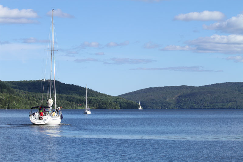
Skuleskogen National Park is a wild and majestic section of Ångermanland’s “High Coast”, where the rolling hills of the Norrland forest meet the northern Baltic Sea. This roadless wilderness offers the visitor magnificent views over sea and forest, beautiful lakes, verdant spruce-clad valleys, and fascinating geological formations which, more clearly than anywhere else, demonstrate how much of modern Sweden has risen from the ancient sea.

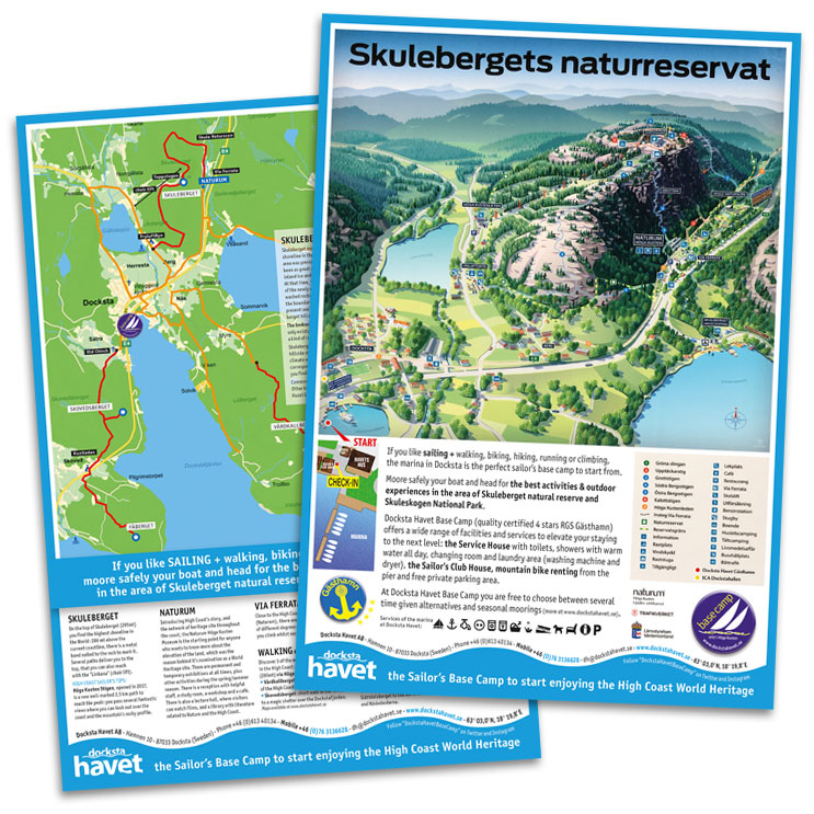
This national park is a heavily undulating rift valley adjoining the coast, featuring forest and outcrops of flat bedrock, in untouched condition where vegetation and animals have been able to develop freely. This area will offer the visitor the opportunity of enjoying fabulous experiences of unspoilt nature. Features especially worth seeing are Slåttdalsskreven, a gorge, 200m long, 40m deep and 7 metres wide, the bronze age cairn, extensive shingle fields, interesting vegetation and, not least, magnificent views of the archipelago. There is a total of thirty kms of marked trails which offer the hiker several alternative circular routes. The High Coast trail crosses the national park. Overnight cabins are located at Skrattaborrtjärn, Lillruten, Tärnättvattnet and Näskebodarna. (Font: www.y.lst.se)


HIGH COAST SAILOR'S TIPS:

Sailing to the heart of the World Heritage: experience Skuleberget and Skuleskogen National Park >


Skuleskogen National Park (1984) and Nordingrå Nature Conservation Area (1983) are classified Category V - Protected Landscape/Seascape: protected area managed mainly for landscape/seascape conservation and recreation - and defined as "Area of land, with coast and sea as appropriate, where the interaction of people and nature over time has produced an area of distinct character with significant aesthetic, ecological and/or cultural value, and often with high biological diversity. Safeguarding the integrity of this traditional interaction is vital to the protection, maintenance and evolution of such an area."

The purpose of Skuleskogen National Park is to preserve in unspoiled condition a coastal landscape of forest, rocky terrain, fissure valleys and steep rolling hills where plant and animal life may develop naturally. (Font: www.naturvardsverket.se)


Skuleskogen is a stupendous area. It combines high mountains, ancient forest and sea coast in a landscape which is without equal in Sweden. Pronounced peaks covered with windswept rocky pine forest are divided by deep rift valleys sculpted by the sea and the inland ice.

There are, in spite of the deserted appearance, traces of human habitation. The oldest of these are Bronze Age burial cairns. The inland ice was unusually heavy here, and pressed the mountains down under sea level. The country has been rising from the sea ever since, to reach today's level of almost 300 metres above sea level. There are also bare boulder fields, swamps and tarns in the park.

The fertile stream valleys are home to many species of bird, such as the very rare grey-headed woodpecker. Several Swedish plants have their most northerly limit in Skuleskogen, for example the decidious trees maple, lime and hazel. The trees are probably relics from warmer ages when deciduous forest was found this far north.

The foremost sights of Skuleskogen are the views of the rolling forest and the sea, Slåttdalsskrevan ravine, Kalottberget mountain with its forested top and treeless slopes, the flora and the Bronze Age burial cairns.

(Font: www.naturvardsverket.se and www.y.lst.se)

Your boat safely moored to start exploring Skuleskogen and Skuleberget

Nordic walking is a fun fitness activity for sailors in the High Coast

hiking and nordic walking on the Skuleberget
Explore the High Coast from Docksta Havet's piers

Nordic walking is a fun and effective fitness activity that crews can integrate into their existing nature walks during their summer cruise on the High Coast

Walking is especially important to rebalance the many hours we spend sitting, working, driving or at home. And of course, after a few days of sailing, a refreshing nature walk can be a great opportunity to "break" the routine aboard. The crews of boats that target the High Coast summer, usually plan several day trips or walks on the beautiful shorelines during a cruise.

Many boats choose to stop a couple of nights in Docksta just for the opportunity to explore Skuleberget mountain. A hike to the top or to the cave, a visit the Naturum Höga Kusten Museum and the area south of Skuleskogen National Park or just the discovering of the surrounding area of Docksta are an excellent opportunity to involve the crew and the family in a different and exciting afternoon.

We noticed that some crews, particularly from Finland, integrate this technique of Nordic Walking into their nature walks, making use of the poles similar to those used in skiing.

Nordic Walking is a form of aerobic training of great effectiveness, which involves much of the upper-body muscles as well as a great overall cardiovascular workout. It activates more core muscles than normal walking, automatically enhancing the strength, muscle power, balance, stability and increased endurance by using the poles.

The technique involves "just" the inclusion of poles in the normal and natural walking. On YouTube you find several videos which - at various levels - illustrate the Nordic Walking technique and how you can experience it.

The specific poles for Nordic Walking are very lightweight and come in two types; one piece non-adjustable version and telescopic adjustable versions. The telescopic poles are adjustable in length according to your height and thus can be easily placed on board. The appropriate equipment should include: the poles, normal hiking shoes and outdoor clothes for walking or trekking.

The possibility to choose the intensity and difficulty of routes makes it an activity suitable for people of all ages and fitness levels. There are several opportunities to practice nordic walking in the surroundings of Docksta so... it's time to moore the boat and take a (nordic) walk! :)


Mooring Rules at the Base Camp

Mooring at the Base Camp
  • We welcome you to the marina of Docksta Havet and we ask you to please follow the rules of the gästhamn.
  • Your pets are very welcome! Please respect other guests and have your dog on leash and pickup after him.
  • It's forbidden to use the onboard toilets with direct jettison. For your personal care please use the toilets and showers of the marina in the Service Hus.
  • It's forbidden to wash the boats sheding the waste water into the sea.
  • Docksta Havet is not a yard: therefore it's forbidden to make refitting on the boats into the Docksta Havet area without permission. Should you need help to contact local assistance for your onboard appliances or the engine, we will be glad to help you :)
  • It's forbidden to trash within the area exausted oil or batteries.

Some useful "Nature-friendly" tips

  • For the maintenance of your boat, try to use products with the highest grade of biodegradability and the lowest impact on the environment.
  • Use preferably "miljöbensin" in your outboard.
  • Keep in good efficiency the engine of your boat, checking also periodically eventual lacking of oil or fuel.
  • Pay attention on filling the tank not to shed fuel in the environment.
  • Proceed at low speed along the shoreline, in order to avoid to produce high waves and acoustic pollution.
  • Pay attention not to damage the sea ground when dropping the anchor.


Höga Kusten: the world's highest uplift of land

The mark of the sea level 9.600 years ago, on the top of Skuleberget

Sweden was entirely covered by inland ice around 20,000 years ago. The High Coast was the area where the land surface was pressed down the most by the vast, three-kilometre wide glaciers.

View of a typical High Coastline. Here is Rotsidan.

From Riksantikvarieämbetet (The National Heritage Board), the agency of the Swedish government that is responsible for heritage and historic environment issues, here below is a complete description of the isostatic uplift that was the key reason for the designation of the High Coast as a UNESCO's World Heritage Site:

The High Coast has the highest uplift of land in the world after a period of inland ice.

Höga Kusten - a view of Rotsidan's shoreline

The land arose from the sea after the ice melted 9,600 years ago. Gradually, plants and animals inhabited it. Humans settled the area and made an impact as well. The serene and peculiar landscape features sweeping mountain lines, steep cliffs over the sea and creeks that meander between the islands.

Sweden was entirely covered by inland ice around 20,000 years ago. The High Coast was the area where the land surface was pressed down the most by the vast, three-kilometre wide glaciers. As the ice began to melt, the land began to rebound, and return to its original position. That is the basic explanation of the nearly 800-metres land rise after the peak of the latest Ice Age, called Weichel.

The area is a unique example of how geological forces have drastically altered a landscape in a relatively short period of time. Special phenomena are hemispheric hills with moraines and caps of woods marking the highest shoreline, 286 metres above present sea level. There are also offshore banks reaching up to 260-metres.

There is a varying plant- and animal life on the land and in the water. For example, there are different forest types, different types of coniferous clumps and rare deciduous trees such as hazel, lime and elm. On the cliffs toward the north, you can find exotic alpine species such as the tufted saxifrage, alpine clubmoss, alpine lady's mantle and the three-leafed rush as well as the unusual plant "strandtraven," which only exists on the High Coast.

The relatively quick land uplift has affected the conditions for human life along the shoreline. There are remains of human settlements and continual human activity during a period of 7,000 years, within a distance of 3 kilometres from the present-day shoreline. The shorelines of different eras contain remains of dwelling-places and human traps from the Stone Age, Bronze Age cairns and burial mounds from the Iron Age, as well as piers and house foundations from previous millennium.

High Coast - a view of the sea merging the countryside

The High Coast was inscribed on the World Heritage list in the year 2000. The motivation of the World Heritage Committee: "The site is one of the places in the world that is experiencing isostatic uplift as a result of deglaciation. Isostatic rebound is well-illustrated and the distinctiveness of the site is the extent of the total isostatic uplift which, at 294m, exceeds others. The site is the "type area" for research on isostacy, the phenomenon having been first recognised and studied there." (Font: Riksantikvarieämbetet - More info here)
Photo on the left: Västernorrlands Länsstyrelsen ©

What is "World Heritage"?

The High Coast was inscribed on the UNESCO's World Heritage list in the year 2000.

The High Coast World Heritage

World Heritage are the cultural and natural sites that are the heritage of humanity. The safeguarding of these sites is the shared responsibility of all. The World Heritage Convention for the protection of the World's Natural and Cultural Heritage was adopted by UNESCO in 1972 and has been ratified by 183 states. There are 830 World Heritage worldwide.

"A World Heritage site is a place of natural or cultural interest which is so valuable that it is important for the whole of humanity. It is a place, site, environment, or object which provides unique testimony to the history of the earth and of mankind. Once inscribed on the prestigious World Heritage List, it is guaranteed protection and care for all time. Sweden has fifteen sites on the list."

This definition is from Riksantikvarieämbetet - The National Heritage Board, the agency of the Swedish government that is responsible for heritage and historic environment issues. (More info)


Heritage is our legacy from the past, what we live with today, and what we pass on to future generations. Our cultural and natural heritage are both irreplaceable sources of life and inspiration. Places as unique and diverse as the wilds of East Africa’s Serengeti, the Pyramids of Egypt, the Great Barrier Reef in Australia and the Baroque cathedrals of Latin America make up our world’s heritage.

What makes the concept of World Heritage exceptional is its universal application. World Heritage sites belong to all the peoples of the world, irrespective of the territory on which they are located.

The overarching benefit of ratifying the World Heritage Convention is that of belonging to an international community of appreciation and concern for universally significant properties that embody a world of outstanding examples of cultural diversity and natural wealth.

The States Parties to the Convention, by joining hands to protect and cherish the world's natural and cultural heritage, express a shared commitment to preserving our legacy for future generations.


The High Coast World Heritage

Heritage and development

It is widely recognised that environmental sustainability corresponds with social and economic prosperity. Environmental degradation is by the World Health Organization directly linked to negative health and development impacts. This is especially the case in poorer countries, where the burden of ecosystem impairment much stronger affects communities that depend on local resources, without the financial abilities to offset the degradation of ecosystem services.
 
The Convention encourages the States Parties to involve local communities in planning and management of properties. Successful protection of heritage depends on the ability to provide opportunities and benefits to the communities within and surrounding the properties.
  
The intention of World Heritage sites is to feature natural and cultural properties of outstanding universal value as well as best practice management plans that may function as models for other protected areas.


The Criteria for Selection

To be included on the World Heritage List, sites must be of outstanding universal value and meet at least one out of ten selection criteria explained in the Operational Guidelines for the Implementation of the World Heritage Convention which, besides the text of the Convention, is the main working tool on World Heritage. The criteria are regularly revised by the Committee to reflect the evolution of the World Heritage concept itself.

(More info about UNESCO's World Heritage mission and the Convention concerning the Protection of the World Cultural and Natural Heritage, adopted by UNESCO in 1972 athttp://whc.unesco.org/en/about/)

The marine realm of the High Coast

The Marine Realm

The marine realm of the High Coast

The biological character of the High Coast's marine environment is a consequence of several major controlling influences such as: brackish waters of very low salinity; the most sharply contoured submarine topography in the Baltic, extending to depths in excess of 200m close inshore; little tidal influence, with shifting water levels determined mainly by changing weather conditions of air pressure and wind; and seasonal ice cover.

Natural environments have undergone dramatic changes since glacial times, passing through marine, brackish and freshwater conditions. The resultant mosaic of shallow, sheltered embayments and deep, open waters provides a range of habitats for a mix of marine, brackish and freshwater species, low in species diversity but high in population numbers for some macrofauna species. Some species are relics of earlier periods, and others are at the extremes of their latitudinal and environmental limits. For the most part, however, the marine biota are described as being typical and representative of that found throughout the Baltic, rather than special or unique.


The special feature of the marine realm, imparting the greatest scientific significance, is that it represents the submarine extension of the topographical continuum of landscapes undergoing isostatic uplift.

Continual elevation of the land results in inlets becoming progressively cut off from the sea, transforming them into estuaries and ultimately lakes (some of which retain their name as bays). Meanwhile, shorelines are constantly reshaped, new islands are born offshore, and others become peninsulas as they unite with the mainland. The terrestrial influence progressively extends seawards into the Bothnian Sea. This process has major effects for the associated plants and animals that must constantly adapt to the changing environments. Thus, the nearshore marine area constitutes an integral part of the ongoing geological evolution of the High Coast and, as such, it is an important natural component of the entire property.

Although the 56% of the size of the High Coast site is marine, only 2% of it is protected: only 15 km2 of the 800 km2 marine component of the area is under protective status.
(Font: UNESCO - World Heritage Nomination - The High Coast (Sweden) - Addendum to 1999 IUCN Technical Evaluation)

The marine realm of the High Coast

The High Coast's terrestrial fauna is typical for the region, but the range of marine habitats provides for a mix of marine, brackish and freshwater species. These are low in diversity but high in populations for some of the macrofauna, some of which are relicts of earlier periods, others at the extremes of their latitudinal and environmental distribution (Dingwall, 2000). All are tolerant of the varying salinity of the brackish water, which off the High Coast ranges between 3 and 6 ‰. There is a major sill across the bottom of the Kvarken Straits at about 25m. Species numbers decline abruptly at the Gulf’s entrance from the Baltic and continue to decrease northwards - from 41 fish species in the Baltic to 20 species in the Gulf and only 6 in the Bay of Bothnia. The consequence is that the northern part of the site is near the northern limit of several species. Two northeastern Atlantic seals are present in the waters off the High Coast, the ringed seal Phoca hispida and the grey seal Halichoerus grypus. The latter occurs in greater numbers, although there are no suitable haul-out areas for the large gatherings of grey seals which are found in the Northern Quark Archipelago and south of the High Coast.

The marine realm of the High Coast

Saltwater and fresh water fish species regularly occur and reproduce along the High Coast within shallow and deep-water areas of the Archipelago. Warm-water species found in shallow waters include perch Perca fluviatilis and roach Rutilus rutilus. Cold-water species of fresh and salt-water origin are the white fish Baltic herring Clupea harengus, salmon Salmo salar, four-horned sculpin and eel pout Zoarces viviparus. Immigrant species include sprat Sprattus sprattus, cod Gadus morhua (VU) and European flounder Platichthys flesus.  Fish are only found in deeper waters in the summer. Shoreline fauna species include the acorn barnacle Balanus improvisus, the common mussel Mytilus edulis, the coralline Electra crustukenta and thefreshwater snail Theodoxus fluviatilis. Shallow water crustaceans include the amphiopods Gammarus zaddachiG. oceanicus at its northern limit, G. salinusPallaseaquadrispinosa, a relict species primarily found in fresh water and Corophium volutator. Several snail species are foundin the mid-archipelago zone: Paludestrina jenkinsiTheodoxus fluviatilisLymnaea peregra and Bithynia tentaculata. The benthic fauna of the deeper waters is dominated by a small number of species. These include the isopod Saduria entomon, the amphipod Monoporeia affinis, the Baltic mussel Macoma bathica, a few semi-pelagic opossum shrimp species (Mysidae) and the common sea snail Liparis liparis. (Font: UNEP-WCMC)

Explore the High Coast with your boat - link back to the main post

Explore the High Coast on your boat

The Höga Kusten is World Heritage also for sailing

The High Coast (Höga Kusten) / Kvarken Archipelago world heritage site

View of the Norrfjärden from the top of Skuleberget

2000: The whole High Coast area was inscribed on the World Heritage List and granted World Heritage status. The area has the largest land uplift of its kind in the world, which was a key reason for the designation of the High Coast as a World Heritage Site.

HK_2082.gif

The High Coast (Sweden) is located on the west shore of the Gulf of Bothnia, a northern extension of the Baltic Sea.
The area covers 142,500 ha including a marine component of 80,000 ha, which includes a number of offshore islands.
The irregular topography of the region - a series of lakes, inlets and flat hills rising to 350 m - has been largely shaped by the combined processes of glaciation, glacial retreat and the emergence of new land from the sea. Since the last retreat of the ice from the High Coast 9,600 years ago, the uplift has been in the order of 285 m which is the highest known 'rebound'. The High Coast site affords outstanding opportunities for the understanding of the important processes that formed the glaciated and land uplift areas of the Earth's surface. (Font: UNESCO - More info at http://whc.unesco.org/en/list/898


In July 2006, the Kvarken Archipelago was inscribed on the World Heritage List, as an extension to the Sweden's High Coast (Höga Kusten). It is the first UNESCO's Natural Heritage Site in Finland. Together, these two areas form a complementary geological complex featuring land uplift unlike anything found elsewhere in the world.


The Kvarken Archipelago, the finnish side extension of the High Coast World Heritage

The Kvarken Archipelago (Finland) numbers 5,600 islands and islets and covers a total of 194,400 ha (15% land and 85% sea). It features unusual ridged washboard moraines, "De Geer moraines", formed by the melting of the continental ice sheet, 10,000 to 24,000 years ago. The Archipelago is continuously rising from the sea in a process of rapid glacio-isostatic uplift, whereby the land, previously weighed down under the weight of a glacier, lifts at rates that are among the highest in the world. As a consequence of the advancing shoreline, islands appear and unite, peninsulas expand, lakes evolve from bays and develop into marshes and peat fens. This property is essentially a "type area" for research on isostasy; the phenomenon having been first recognized and studied here. We congratulate Finland with the inscription of Kvarken on the World Heritage List! (from: Nordic World Heritage Foundation - Newsletter August 2006)
Photo on the left: Tuukka Pahtamaa ©

Land uplift in the Kvarken is very intense and the archipelago is constantly changing shape. New islands emerge from the sea, bays are transformed into lakes and shipping lanes become shallower. Since the land surface increases by a hundred hectares a year, these changes can be noticed during one generation. See more about "The Kvarken Archipelago - a World Heritage" at the Finnish Ministry of the Environment website. And here is the link to The Kvarken region picture gallery. But don't miss to visit The Kvarken Nature Guide!
 
Both High Coast and Kvarken Archipelago are inscribed on the World Heritage List under Natural Criterion viii: "to be outstanding examples representing major stages of earth's history, including the record of life, significant on-going geological processes in the development of landforms, or significant geomorphic or physiographic features".

They are also legally gazetted as "protected landscape/seascape" of IUCN management categories.

The distance between the areas is 150 kilometres.

See also: The Kvarken Archipelago and The High Coast World Heritage Site at www.kvarken.fi.

Explore the High Coast with your boat - link back to the main post

Explore the High Coast on your boat

The Höga Kusten is World Heritage also for sailing